File Upload
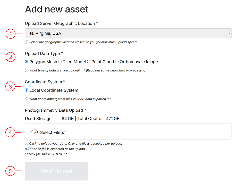
Upload Configuration Options
Section titled “Upload Configuration Options”1. Select Server Location
Section titled “1. Select Server Location”Choose the server closest to your physical location for optimal upload speeds. Available locations:
- USA: North Virginia
- UK: London
- Germany: Frankfurt
2. Choose Data Type
Section titled “2. Choose Data Type”Select the type of data you’re uploading from these supported formats:
- Polygon Mesh
- Tiled Model
- Point Cloud
- Orthomosaic Image
3. Specify Coordinate System
Section titled “3. Specify Coordinate System”Indicate which coordinate system your data uses.
- Polyhon Mesh: Currently only Local Coordinates are supported.
- Tiled Model: Local Coordinates or Georeferenced in WGS84 (EPSG:4326) are supported.
- Point Cloud: Local Coordinates or Georeferenced in WGS84 (EPSG:4326) are supported.
- Orthomosaic: Georeferenced in WGS84 (EPSG:4326) is supported.
4. Prepare Your File
Section titled “4. Prepare Your File”Select the file to upload (one at a time). For best results, compress files before uploading:
- Accepted compression formats: .zip, .rar, .7z
5. Initiate Upload
Section titled “5. Initiate Upload”After configuring all options, click “Start Upload”. Track progress on your User Profile Asset List page.
Best Practices for Successful Uploads
Section titled “Best Practices for Successful Uploads”File Preparation Tips
Section titled “File Preparation Tips”- Compress files before uploading to reduce transfer time
- Verify coordinate system compatibility
- Check file integrity prior to upload
- Use clear, descriptive filenames
Supported Compression Formats:
- ZIP (.zip)
- RAR (.rar)
- 7-Zip (.7z)
Upload Optimization Tips
Section titled “Upload Optimization Tips”- Select nearest server location for fastest speeds
- Consider off-peak hours for uploads
- Maintain stable internet connection
- Monitor progress without closing the browser tab
Processing Times: (For large and complex datasets, expect longer processing times)
- Point Clouds: 5-15 minutes
- Polygon Mesh: 30-90 minutes
- Tiled Models: 15-45 minutes
- Orthomosaic Images: 20-60 minutes