About
Construkted Reality
The workspace for 3D capture: private for your team, discoverable to the world.
What it is
Construkted Reality is a browser-based 3D geospatial collaboration platform: the review-and-handoff layer for 3D capture, the way Frame.io is for video. It turns large capture data (point clouds, photogrammetry meshes, tiled models, orthomosaic imagery, and Gaussian splats*) into a link anyone can open in a browser, with measurement, annotation, and project collaboration built in. It's as easy to send as a Dropbox link, except the scan opens with your findings on it. No installs, no specialist software on the viewer's end. *Gaussian splat support is releasing very soon.
It's built around one workflow: capture once, interpret freely, discover together. Your captured data becomes an asset that is never overwritten. Everything you add (measurements of distance, area, and volume, notes, drawings, discussion) lives in a project layer that references the capture. The work stays reviewable, reusable, and honest to the original scan.
Two sides, one engine
The private workspace is the product you pay for. A team, or a team of one, uploads scans, measures, annotates, and hands off to clients, private by default. The public side is what grows: any asset or project can be published to a place-pinned page that's free for anyone to find and view. Discovery is never paywalled; we charge for utility: private work, storage, seats.
Where this is going
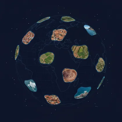
Every public capture is a piece of something bigger: a community-built, OpenStreetMap-inspired 3D record of real places. The long-term direction is a Globe you can browse, assembled bottom-up from what people choose to share, with every contribution credited to the person who captured it. That's the horizon we're building toward, and public assets on Construkted Reality are its first pieces.
What it isn't
- Not a replacement for CAD, BIM, or GIS. Construkted Reality is the review, handoff, and collaboration layer for 3D capture. It sits alongside your authoring and survey tools It doesn't replace where you certify the work.
- Not a capture tool. There's no scanning app. You capture with whatever you already fly or carry, then bring the data here to share it.
- Not a public showroom by default. Client work stays private. Publishing is an explicit act, and nothing is discoverable unless you choose it.
How it's run
Construkted Reality is an independent, for-profit software product. Paid plans fund the storage, hosting, and viewer that make large scans shareable. The company is built for the working professionals who use it: surveyors, AEC teams, drone operators, and the heritage and GIS practitioners documenting real places.
A 3D record of real places, built by the people who capture them.
If you scan the world, professionally or for the love of it, your work can stay private or become part of the map.
Start free